 By Deborah Van Hoewyk
Oh, those mysterious Maya! Google “mystery” and Maya” and in less than half a second, you get more than 12 million hits. There are lots of little mysteries, being solved every day by archaeologists and anthropologists working in the Mayan ruins spread across what is now Chiapas, the Yucatán, Belize, Guatemala, and the western borders of Honduras and El Salvador. To the Maya, we owe the wonders of Chichén Itzá (Yucatán), Palenque (Chiapas), Tikal (Guatemala), Caracol (Belize), Copán (Honduras), and hundreds more places where ancient stones rise out of hillocks in the tropical jungle.
So What Don’t We Know?
The first BIG mystery: Why did the Maya become a major Pre-Hispanic civilization? The Maya and their precursor peoples were present in Mesoamerica from some 2500 years before Christ (the Pre-classic Period, 1800 BC – 250 CE). Most descriptions portray these people as isolated in their rather simple life; there is little evidence for alliances with other Mayan groups, or contact beyond the region.
But then there was a Mayan “Renaissance” starting around 250 CE. Little villages turned into urban centers, some of those turned into city-states. The Maya separated themselves into social classes led by a ruling elite, and greatly developed their arts, sciences, and a coherent hieroglyphic script. While the Dark Ages settled over Europe, and the great central Mexican city of Teotihuacán already lay in ruins, the Mayan civilization produced huge pyramids to anchor their cities. They systematized their hieroglyphics into a written language, and kept records on bark paper. They had the concept of zero down, created a multi-cycle calendar system, and developed a cosmology that governed architecture and agriculture. On the downside, the larger cities became rivals and frequently went to war against one another, with more and more savage practices as time went on.
This Classic Period lasted until about 900 CE, and then—the second BIG mystery. What happened to the Maya? Why did they disappear from their wonderful cities? The Maya certainly did not die out—there are about 7 million of them still living where they have always lived.
A broad range of theories has been proposed. Did the Classic Mayan penchant for warfare, which eventually included sacrificing all members of defeated ruling families, lead to total governmental breakdown? Did some cities use warfare to eliminate their rivals, and continue as strong and successful population centers—research indicates that Uxmal and or Chichén Itzá may have done so, surviving nicely until the Spanish conquest. Perhaps non-Mayan groups took over some sites—there’s some evidence of this at sites along the Usumacinta River. Maybe internal social upheaval—although there’s not much to support that hypothesis. External forces such as epidemics, natural disasters, and ecological failure have all been considered as well, with some evidence for the ecological idea—signs of long droughts, over-cultivation, and deforestation.
 The Trade Hypothesis
Lately, however, researchers have begun to consider trade as a factor in the mysteries of both the rise and the collapse of Classic Maya civilization. Contacts with other cultures would explain the “renaissance”—as cultures observe each other, it’s pretty much a given that both will change. And changes in or loss of trade routes would undermine cities already struggling with other problems; evidence does indicate an overall shift from Highland to Lowland trading centers.
The specialized resources available to the Maya gave them a “comparative advantage” in trade—from the Highlands came minerals—obsidian, jade, cinnabar—used for weapons, tools, jewelry, and art objects. Unique items like quetzal feathers from the Highlands and carved shells from both the Pacific and Yucatán Lowlands. Precious salt came from desalinization platforms or boilers all along the Pacific and Atlantic shorelines, as well as a black brine dome in the Highlands of Guatemala. The Maya exported cotton, furs and leather, honey and cacao, and more. And the specialized crafts that produced finished goods for export did a lot to help create a well-off middle for the class system that developed as Mayan culture flourished.
Trade traveled by sea along the coastlines; on the Atlantic, seagoing Mayan canoes traveled as far as present-day Veracruz before the traders turned inland and went by land to Mexico City. On the Pacific coast, trade reached from Honduras to present-day Huatulco. Overland trade was carried by porters or pack animals (the wheel appears only on Mayan toys) on sacbeob (singular sacbe), or raised roads paved in white stucco; most of the sacbeob were intended to connect temples and other key structures within individual cities, but there are indications of a few long-distance roads between cities.
Rivers Made the Richest Trade Routes
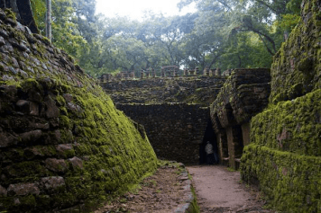
But the trade that carried precious cargo from the Highlands to the Lowlands went mostly by river, carried by large canoes. And the greatest of these trade routes was the Usumacinta River, which forms part of the border between Mexico and Guatemala and is named (in Mayan) after the howler monkeys that fill the jungles around the remote ruins of Yaxchilán (Chiapas) and Piedras Negras (Petén region of Guatemala).
The Usumacinta starts in the Highlands in Guatemala, and flows northward down to the Lowlands, joins the Grijalva in Tres Bravos, Tabasco, forming a delta and the wetlands of Centla on the Gulf of Mexico. (The Grijalva flows to the west of the Usumacinta, from the Highlands of Chiapas down through Chiapa de Corzo and north of Tuxtla Gutiérrez through the Sumidero Canyon, towards the Gulf.
Yaxchilán (bottom star on the map) is situated on an “oxbow” in the Usumacinta; most visitors reach it by traveling to Frontera Corozal in Chiapas, and taking a 45-minute boat ride down the river, serenaded by those howler monkeys. (See The Eye, May-June 2013, “Lakes and Rivers of Mexico: Magical Moments,” for an impression of the experience.) Piedras Negras (middle star on the map) is located 25 miles or so past Yaxchilán, in Guatemala’s Sierra del Lacandón National Park; and is reached by boat, also from Frontera Corozal or from Bethel, farther upstream in Guatemala.
In a 2012 article in the Journal of Mesoamerican Studies, Charles Golden et al. counted 14 Mayan cities on the Usumacinta, and another 28 with easy access to the river, mostly by water. This makes 42 shipping points with access to each other and the Gulf of Mexico trade routes.
Not that it was an easy float down the river—the Usumacinta is a fast river, it’s hard to navigate with heavily loaded, flat-bottomed canoes, and there are rapids between Yaxchilán and Tenosique (top star on the map) in Tabasco. At least eight big rapids, through narrow canyons, some of them so bad that Mayan traders usually opted to portage their cargo around them. (Comparative study of aboriginal use of United States rivers indicates that it would have been possible to cross these rapids in trade canoes, but nothing has been found to confirm it.) Afterwards, of course, the canoes had to come back UP the river, fighting the current all the way.
Yaxchilán’s “oxbow” location, that is, on a high point formed as the river encircles the site in the shape of a Greek omega (Ω), gives rise to one of the most surprising Mayan technological achievements. When the river crested with the rain, it made Yachilán into an island. So, the Maya built what might be the world’s first formal suspension bridge—certainly the longest in the ancient world—running north to the Guatemalan side of the river where Yaxchilán’s agricultural fields lay.
When American structural and forensic engineer James O’Kon, who has long studied Mayan construction technology, visited Yachilán, he noticed a rock structure on the southern shoreline. Looked like a bridge base to him, so he turned to the north shore, where he did indeed see a much deteriorated pile of stones. After studying the stones, O’Kon integrated archaeological studies and aerial photos to produce a computer model of the bridge. It had support structures on the banks, and two piers 12 feet square and 35 feet tall located 600 feet apart in the river. The bridge itself was made of woven hemp.
Downriver, Piedras Negras had an uneasy relationship with other Mayan cities, with evidence of a war with Yaxchilán (795 – 808 CE), won by Yaxchilán, which resulted in an alliance between the two cities. The most logical reason for war and the subsequent alliance was Piedras Negras’ control of trade, both on the river and overland from the interior.
Piedras Negras overlooks the Usumacinta with more than half a hundred outlooks cut into the cliffs. From the Acropolis, you can see at least a mile up and down the river. Canoes—be they war canoes or trading canoes—would be readily observed. The stories of Piedras Negras were deciphered from hieroglyphs by Russian-born, U.S. educated architect Tatiana Proskouriakoff; her work provided keys to all subsequent decoding of Mayan hieroglyphs. (Her ashes are interred at Piedras Negras.)
Alas, perhaps because it is so remote, feasibly approachable only from the river, Piedras Negras was subject to intense looting in the 1960s, as well as occupation by squatters and drug cartels in the 2000s. All that seems to have died down, but it still a challenge to visit: “This is a trip only for the experienced and adventuresome,” explains the website http://www.mayan-ruins.org. “You must travel to the site by a long, difficult and perilous boat trip which can be arranged at Frontera Corozal, Mexico. Not all the boats are willing to make the trip.”
But if you go, you will get a taste of what it must have been like to guide baskets filled with shimmering piles of jade ornaments and quetzal feathers down the Usumacinta in 750 CE.